A detailed map of Wilson Township and Ludington Township in Eau Claire County
The Town of Ludington and Town of Wilson is north of the Town of Bridgecreek
The Township map is best and most fully seen on large screen monitors with a resolution of 1680 x 1080 or larger See lists below this township map for a list of all features.
To display the Wilson Township and Ludington Township map clearly in full size, click on the image, right click, view image
See the Fall Creek WI Business Directory and Augusta Wis Business Directory for Business Addresses and Phone Numbers near by the Town of Ludington
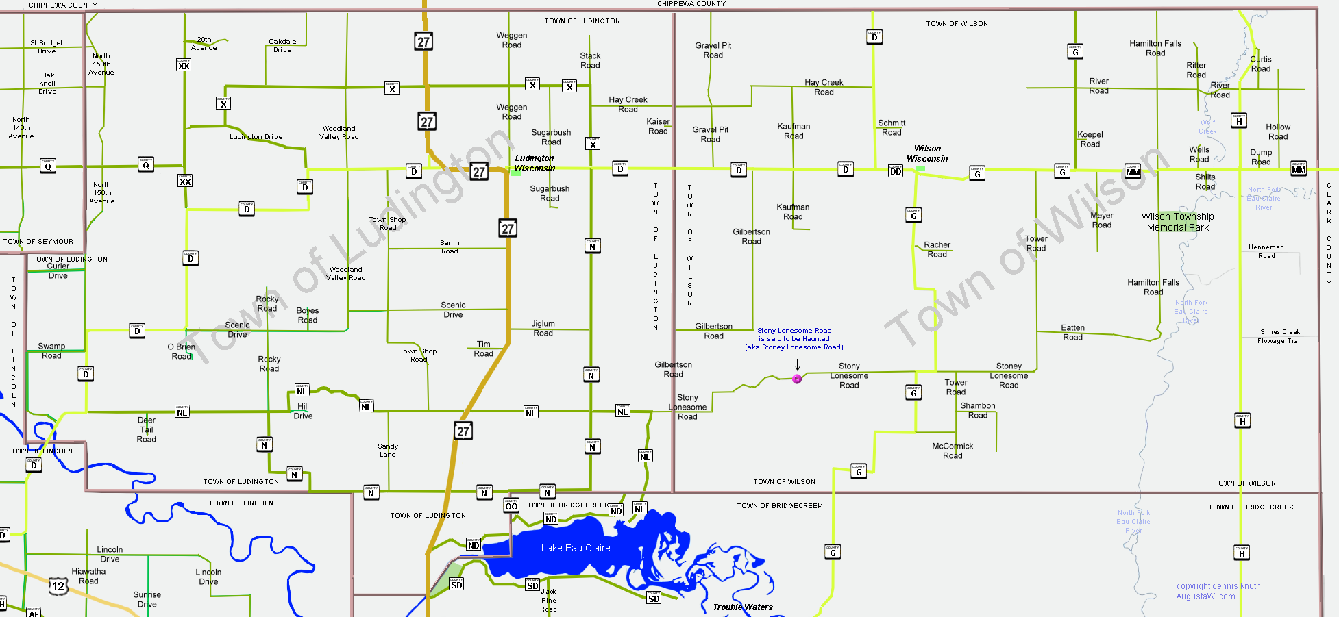
Augusta Wisc and Fall Creek Wisconsin are nearby the townships. Stony Lonesome Road (aka Stoney Lonesome) is said to be haunted. Curiously, Stony Lonesome is directly north of the Green Eyes Bridge on the other side of Lake Eau Claire and the Eau Claire River. The Green Eyes Bridge, in the Eau Claire County Town of Bridgecreek, is said to be haunted too.
Highways, Wisconsin State Roads and County Roads in the in the Town of Ludington
| Country Road D County N County ND County NL |
County NL County OO County Q County SD |
County X County XX Wisconsin State Highway 27 |
Named Roads and Byways in Eau Claire County Wisconsin Town of Ludington
|
140th Avenue, North 150th Avenue, North 20th Avenue Berlin Road Boyes Road Curler Drive Gilbertson Road Hay Creek Road Hiawatha Road Hill Drive |
Jiglum Road Kaiser Road Lincoln Drive Ludington Drive Oak Knoll Drive Oakdale Drive O'Brien Road Rocky Road Sandy Lane Scenic Drive |
St Bridget Drive Stack Road Stony Lonesome Road Sugarbush Road Sunrise Road Swamp Road Tim Road Town Shop Road Weggen Road Woodland Valley Road |
Areas, Campgrounds, Parks and Locales identified by a common name
| Ludington Wisconsin Community |
Areas that Border on the Town of Ludington in Eau Claire County
| Chippewa County Town of Wilson |
Town of Bridgecreek Town of Seymour |
Town of Lincoln |
Rivers, Creeks, Ponds and other Waterways in Ludington Township
| Eau Claire River | Sand Creek |
_______________________________________________________
County Roads and Highways in the Town of Wilson
| Country Road D County DD |
County G County HH |
County MM |
Named Roads and Byways in Eau Claire County Wisconsin Town of Wilson
|
Curtis Road Dump Road Eatten Road Gilberson Road Gravel Pit Road Hamilton Falls Road Hay Creek Road |
Henneman Road Hollow Road Kaufman Road McCormick Road Meyer Road Racher Road Ritter Road |
River Road Schitt Road Shambon Road Simes Creek Flowage Trail Stoney Lonesome Road Wells Road |
Areas, Campgrounds, Parks and Locales identified by a common name
| Wilson Wisconsin Community | Town of Wilson Memorial Park |
Areas that Border on the Town of Wilson in Eau Claire County
| Chippewa County Town of Ludington |
Town of Bridgecreek |
Clark County |
Rivers, Creeks, Ponds and other Waterways in Wilson Township
| Eau Claire River North Fork | Wolf Creek |
The map of Ludington Township and map of Wilson Township area is not drawn to scale. It is hand drawn and locations are approximate. Information is culled from many sources. Its currency may not be up-to-date because some of the sources are not up-to-date.